
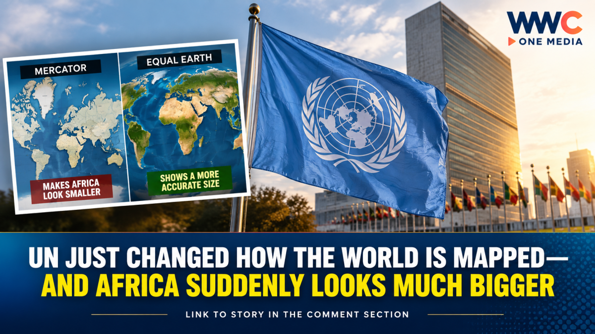
The world map millions of people have grown up seeing could soon look very different.
The United Nations General Assembly has overwhelmingly backed a resolution promoting a new way of depicting the world—one that gives a far more accurate picture of the relative size of continents, particularly Africa.
The resolution, led by Togo and backed by African countries, passed on September 4 with 164 votes in favor, one against and six abstentions. The United States was the only country to vote against it.
But there is an important catch: the UN has not banned the traditional Mercator projection. The resolution is not legally binding. Instead, it encourages governments, schools, international organizations, media companies and technology platforms to consider more accurate alternatives, particularly the Equal Earth projection.
Why Africa suddenly looks so much bigger
The controversy centers on the Mercator projection, created by Flemish cartographer Gerardus Mercator in 1569.
Mercator’s map was designed primarily for maritime navigation. It preserves directions and angles in ways that were extremely useful to sailors, but that comes with a major trade-off: the farther a region is from the equator, the more its apparent size is exaggerated.
That means northern regions such as Greenland, Europe and parts of North America can appear dramatically larger than their actual land areas, while equatorial regions—including Africa and South America—appear comparatively smaller.
One of the most striking examples is Greenland.
On a conventional Mercator map, Greenland can appear roughly comparable in size to Africa. In reality, Africa is about 14 times larger than Greenland.
The distortion becomes even more obvious when comparing the continents themselves.
Enter the Equal Earth map
The UN resolution promotes the Equal Earth projection, developed in 2018 by cartographers as an equal-area alternative.
Unlike Mercator, Equal Earth is designed to preserve the relative surface areas of continents. As a result, Africa appears substantially larger, while the apparent size of regions closer to the poles is reduced. Latin America, South Asia and Oceania also gain a more proportionate visual presence.
That does not mean Africa has suddenly become bigger.
The continent’s physical size has never changed.
What changes is the way that size is represented on a flat map.
And that distinction matters.
There is no perfect way to flatten a spherical Earth onto a two-dimensional sheet without introducing some form of distortion. Different map projections prioritize different things—such as area, shape, distance or direction.
Mercator prioritizes navigation. Equal Earth prioritizes a more accurate comparison of land areas.
Why the United States voted against it
The vote also produced an unexpected political headline.
The United States was the only country to vote against the resolution, while six countries—including Ukraine—abstained.
U.S. representatives criticized the initiative as an ideological exercise and argued that the UN should focus on more pressing international problems rather than map projections dating back centuries.
Supporters of the resolution see the issue very differently.
Togo’s Foreign Minister Robert Dussey has argued that maps influence how people understand the world and that distorted representations can contribute to distorted perceptions.
The African-led campaign is therefore about more than cartography. Supporters describe it as an effort to correct a longstanding visual imbalance in how Africa and other regions are represented in classrooms, media and public institutions.
France is already moving away from Mercator
The UN vote comes as several governments are reconsidering how they portray the world.
France announced that it would abandon the Mercator projection in favor of representations more faithful to actual surface areas. France plans to use the Eckert IV projection, which is also an equal-area projection and shares the goal of representing continental sizes more accurately.
French Foreign Minister Jean-Noël Barrot argued that maps can influence perceptions of global importance and said correcting a distorted representation was an important step.
Will Google Maps and school textbooks change?
Not immediately—and this is where some headlines about the UN decision can be misleading.
Because the General Assembly resolution is non-binding, it does not force Google, Apple, schools, governments or private mapmakers to stop using Mercator.
Mercator will also remain useful for navigation, where its properties are still valuable. The resolution specifically does not challenge its use for maritime and aerial navigation.
However, the vote could accelerate changes in educational materials, institutional maps, media graphics and digital platforms.
Togo has said it intends to change its own school geography materials by the end of the year and plans to encourage other governments, organizations and technology companies to follow.
The bigger question behind the map
The debate ultimately goes beyond geography.
For generations, students around the world have looked at maps that visually enlarge the northern parts of the planet while reducing the apparent scale of regions around the equator.
Supporters of the Equal Earth movement argue that these visual distortions can subtly influence how people perceive the relative importance of different parts of the world.
Critics counter that the Mercator projection was created for a practical navigational purpose—not to deliberately diminish Africa—and that no flat map can perfectly represent every aspect of a three-dimensional planet.
Both points can be true.
Mercator is not a useless or “wrong” map. It is simply designed for a different purpose.
And Equal Earth is not a newly discovered version of Earth. It is another projection designed to show something Mercator does not: the relative area of the world’s landmasses more faithfully.
So, did the world map really change?
Yes—and no.
The Earth itself obviously has not changed.
The United Nations has not ordered every map in the world to be replaced.
But the UN General Assembly has now given overwhelming international support to an initiative encouraging a more accurate visual representation of the world’s continental land areas.
And that could eventually change what millions of people see in classrooms, newsrooms, institutions and digital platforms.
For Africa, the symbolism is enormous.
The continent did not suddenly become bigger.
The world is simply being encouraged to see how big it already was.
WWC ONE MEDIA J.M.S



Leave a Reply