
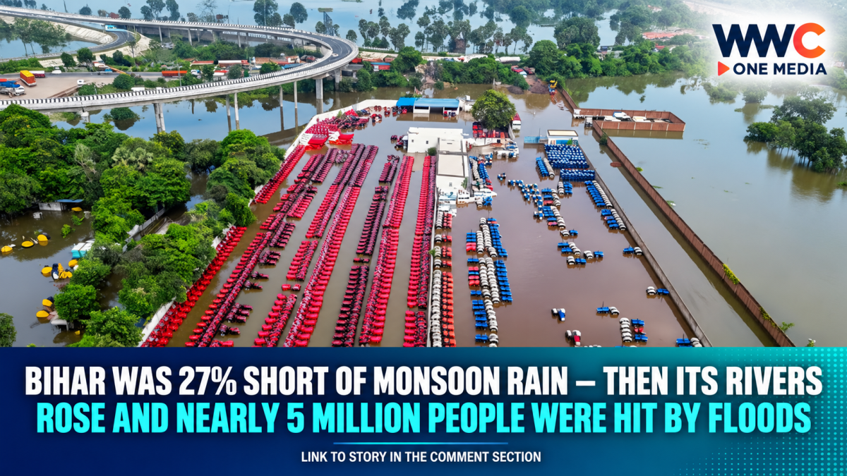
PATNA, India — Nearly five million people across Bihar are now living with floodwater around their homes, farms and roads in a disaster made more striking by one uncomfortable fact:
For much of this year’s monsoon, Bihar was actually short of rain.
Yet by mid-September, the eastern Indian state was dealing with one of its widest flood emergencies of the season.
About 4.97 million people across 15 districts have been affected, according to the latest state figures reported on Sept. 15, while water at gauges on several of Bihar’s major rivers remained above danger levels.
More than 827,000 flood-affected families have been approved for ₹7,000 each in direct financial assistance.
The state says approximately ₹579 crore is being transferred to affected households.
Hundreds of villages remain surrounded by water.
Farmland has been submerged.
Workers have lost income.
Families have moved onto rooftops, roads, embankments and temporary shelters.
And although water has begun receding in some rivers, the crisis is far from over.
The strange part is how quickly the story changed.
As recently as early September, Bihar had been confronting something closer to drought conditions.
Then the rivers rose.
Nearly five million people are affected
CNA, citing Bihar’s Disaster Management Department, reported that nearly five million people had been affected by Sept. 15.
A separate state update reported 49.67 lakh people — 4.967 million — across 15 districts, with around 575 gram panchayats affected.
Among the areas repeatedly identified in official and PTI-backed reports are Patna, Bhojpur, Saran, Vaishali, Bhagalpur, Begusarai, Buxar, Samastipur, Munger, Katihar, Lakhisarai, Khagaria, Purnea and Madhepura.
Because recent reports differ slightly over the final district included in the count, the safest current description is simply 15 affected districts, rather than presenting one list as definitive.
The scale has expanded extremely quickly.
On Sept. 5, a little over 1.6 million people were reported affected.
By Sept. 9, that number had climbed beyond 4 million.
By Sept. 15, it was approaching 5 million.
That is not simply a river rising.
It is a disaster spreading across one of India’s most densely populated states.
All seven major river systems were above danger thresholds
CNA reported that monitoring points on all seven of Bihar’s key rivers were above their designated danger levels on Tuesday.
The affected river network has included the:
Ganga, Kosi, Gandak, Burhi Gandak, Bagmati, Punpun and Ghaghara.
At Sultanganj in Bhagalpur, the Ganga stood at 36.21 metres early on Sept. 14 — 1.71 metres above its danger mark, according to the latest PTI-backed state update.
The Kosi was above danger level at Baltara and Kursela.
The Burhi Gandak was above its threshold at Khagaria.
The Bagmati was high at Benibad.
The Punpun was above danger level at Sripalpur.
And the Ghaghara remained elevated at Darauli.
Those are not isolated rivers.
They form a connected network across Bihar’s enormous floodplain.
That is why one swollen river can create problems far beyond its own banks.
The Ganga has been the central problem
This year’s flood pattern has been particularly unusual because the Ganga rose first and rose extremely high.
Bihar officials told The Indian Express that in a more typical flood sequence, rivers flowing from Nepal — including the Bagmati, Kamla, Kosi and Gandak — rise before the Ganga becomes the primary concern.
This year, the sequence was reversed.
At Gandhi Ghat in Patna, the Ganga reached 50.58 metres, six centimetres above its previous highest flood level of 50.52 metres recorded in 2016.
At Sultanganj in Bhagalpur, it reached 36.80 metres, five centimetres above the previous record set in 2021.
Those may sound like tiny differences.
For a river already at record height, centimetres matter.
Once water exceeds embankments, floodplains or drainage thresholds, a small vertical increase can spread horizontally across huge areas.
Bihar was 27% short of rain before the floods
This is the part that makes the 2026 disaster particularly counterintuitive.
Between June 1 and Sept. 8, Bihar received about 601.1 millimetres of rain — 27% below normal, according to meteorological data cited by The Indian Express.
As late as Sept. 1, the deficit had been around 30%.
So Bihar did not spend the entire monsoon being overwhelmed by record statewide rainfall.
Quite the opposite.
For much of the season, inadequate rainfall was a concern.
Then conditions changed rapidly.
September rainfall arrived hard and fast
While total monsoon rainfall remained deficient, September brought much heavier localised downpours.
The Indian Express reported that rainfall during September was 31% above normal at the point when flooding intensified.
Some locations received extreme individual rain events.
East Champaran recorded roughly 214.9mm in one such event.
Sitamarhi received about 154.6mm.
By Sept. 14, Bihar’s local weather office said 111.7mm had fallen during September to that date, above the normal amount for the period.
That helps explain the apparent contradiction.
A state can have a below-normal monsoon overall and still experience catastrophic flooding if a large portion of rain arrives intensely over a short period — especially when rivers are also carrying water from enormous upstream catchments.
Much of the Ganga’s water did not fall in Bihar
This is another critical point.
A river does not care where political boundaries are.
The Ganga’s drainage basin extends far beyond Bihar.
Water falling hundreds of kilometres upstream eventually travels downstream.
Bihar officials identified heavy rainfall around Prayagraj and Varanasi in Uttar Pradesh as an important contributor to the rising Ganga.
Rainfall in Jharkhand also contributed to high Punpun flows.
At the same time, rivers originating in or passing through Nepal continued carrying additional water into Bihar.
So measuring rainfall only inside Bihar cannot fully explain Bihar’s floods.
The river basin is much larger than the state.
Nepal is part of the story — but not the whole story
CNA noted that Bihar lies downstream from Nepal, which experienced catastrophic flooding after the Aug. 26 Himalayan disaster.
That connection needs careful wording.
It would be misleading to say the Nepal-Tibet disaster simply caused Bihar’s current statewide floods.
Bihar officials told The Indian Express that the Gandak initially rose after the Himalayan event, prompting all 36 gates of the Valmikinagar barrage to be opened.
Its discharge reached roughly 150,200 cubic feet per second on Aug. 26 before falling.
But Bihar’s major flooding continued after those flows declined.
Officials instead point to a combination of factors:
heavy local September rainfall;
upstream rainfall in neighbouring Indian states;
river flows from Himalayan and Nepal catchments;
and especially the extraordinarily high level of the Ganga.
The swollen Ganga created a “backwater effect”
This may be the most important hydrological explanation.
Rivers such as the Gandak and Punpun eventually need to discharge into the Ganga.
Normally, their water flows downstream into the larger river.
But imagine trying to empty a smaller pipe into a larger pipe that is already full.
The water has nowhere to go.
Bihar Water Resources officials described that as a backwater effect.
When the Ganga rose extremely high, tributaries found it more difficult to drain.
That can raise water levels upstream and worsen flooding even in locations that did not receive the heaviest rainfall themselves.
It is one reason river floods can behave very differently from simple rainwater accumulation.
The land itself makes Bihar vulnerable
Bihar occupies an enormous alluvial plain created over millennia by Himalayan river systems.
Much of northern Bihar is extremely flat.
The Gandak, Kosi, Bagmati and Burhi Gandak descend from Himalayan and Nepal catchments and enter plains where water moves much more slowly.
The Ganga then crosses Bihar from west to east, linking a broad belt of vulnerable floodplain districts.
This geography has benefits.
River sediment produces fertile agricultural soil.
But it also creates enormous flood exposure.
When rivers overflow, there are few steep gradients to carry water away quickly.
The rivers carry huge amounts of sediment
Flood management becomes even more complicated because Bihar’s rivers are extremely sediment-heavy.
Water flowing from the Himalayas carries sand, silt and other material downstream.
Over time, sediment can accumulate inside river channels.
That raises riverbeds and reduces the amount of water a channel can contain before overflowing.
Bihar Disaster Management Department Principal Secretary Santosh Kumar Mall described sediment as a permanent challenge for the state’s rivers.
It cannot simply be treated as an occasional maintenance problem.
It is part of the physical geography of the Ganga basin.
Bihar has more than 3,700km of embankments
The state has tried for decades to contain flooding with engineered barriers.
Officials say Bihar has constructed more than 3,730 kilometres of river embankments, protecting around 3,600 square kilometres of land historically.
Authorities said no major modern embankment suffered a catastrophic breach during the recent episode.
Yet communities can still flood.
Water can enter low-lying areas through drainage channels.
Older structures can overtop.
Seepage can occur.
Local erosion can damage roads and access points.
And rivers can simply rise around inhabited floodplain areas outside the most heavily protected zones.
That is why an embankment does not make a floodplain flood-proof.
Around 55,000 hectares may be inundated
The damage is not confined to houses.
Chief Minister Samrat Choudhary said on Sept. 15 that around 55,000 hectares of land had been inundated, causing crop losses.
That figure is significant because agriculture remains central to Bihar’s rural economy.
Floodwater arriving before harvest can destroy standing crops.
Even after the water disappears, farmers can face:
damaged soil;
lost seed;
dead livestock;
destroyed irrigation infrastructure;
erosion;
and debt accumulated during a season that produced little or no income.
This is why the central government’s assessment team is being led by India’s agriculture minister.
New Delhi is now assessing the damage
Union Agriculture and Farmers Welfare Minister Shivraj Singh Chouhan travelled to Bihar on Sept. 16 with senior officials to inspect flood damage, including losses to crops and rural infrastructure.
The programme includes aerial surveys and visits to affected villages and relief camps.
Chouhan is also scheduled to review the response with Bihar Chief Minister Samrat Choudhary and state officials.
The assessment matters because the final documented scale of crop, road, housing and infrastructure damage can influence the amount and form of additional central assistance.
That figure is not yet final.
More than 827,000 families are already receiving cash
Bihar has moved more quickly on immediate household assistance.
The state identified 827,472 flood-affected families for direct cash transfers of ₹7,000 each.
That represents approximately ₹579.23 crore in relief payments, according to the state figures reported by Patna Press.
Chief Minister Choudhary said eligible households missed during the initial identification process should also be added.
The money is intended as immediate relief.
It is not compensation for the full value of homes, crops, livestock or income lost during the floods.
For a family whose house or harvest has been destroyed, ₹7,000 is emergency support rather than reconstruction funding.
More than 1,000 community kitchens are operating
The logistical operation is also large.
CNA reported that Bihar had opened 13 relief camps, was operating more than 1,000 community kitchens and had deployed nearly 1,800 boats across affected areas.
A Sept. 14 state update gave the number of community kitchens as 1,260, with around 11,060 people receiving shelter, food, medical assistance and other support at relief centres.
Ten teams from India’s National Disaster Response Force and 27 teams from the State Disaster Response Force had also been deployed.
Those numbers reveal the scale of the emergency.
But they also reveal why access becomes one of the most difficult parts of flood response.
Roads become useless long before villages become empty
Floodwater does not have to destroy a road to cut off a community.
A metre of water can make a normal road impassable.
A damaged culvert can isolate an entire village.
A submerged bridge approach can stop ambulances even when the bridge itself remains intact.
That is why boats become essential.
In Katihar, where hundreds of thousands of people have been affected, health teams have been using boat ambulances to deliver medicines and treatment to communities surrounded by water.
Flood rescue therefore becomes partly a transportation problem.
Food can exist in a warehouse.
Medicine can exist in a hospital.
But neither helps a village if there is no safe way to reach it.
Clean drinking water may become as urgent as rescue
Residents interviewed by CNA described shortages of safe water, food and milk.
Chandan Kumar Mahto, a 46-year-old resident of Saran district, said people faced the same problem repeatedly during floods: essential supplies become difficult to obtain even when the water is everywhere.
That is one of flooding’s cruellest contradictions.
There can be water in every direction and nothing safe to drink.
Floodwater can mix with:
sewage;
animal waste;
fuel;
agricultural chemicals;
and contaminated wells.
Once that happens, diarrhoeal disease and other waterborne illnesses can become a second disaster.
That is why state officials say clean drinking water and medicines are among the supplies being prioritised.
Families are living on roofs and embankments
CNA described residents forced onto elevated spaces after water entered homes.
Lakhmania Devi, 42, from Vaishali district, said her family sheltered on a roof after their house flooded.
She described living without a functioning kitchen and relying on unsafe water.
These situations are common in large river floods because evacuation is not always immediate.
Families often resist leaving homes because they fear losing livestock, grain, documents or other possessions.
Others have nowhere obvious to go.
Some move repeatedly as water rises.
That is why official counts of people in relief camps capture only part of the actual displaced population.
Many flood victims shelter with relatives, on embankments or on elevated roads rather than inside formal camps.
The economic impact hits daily-wage workers almost immediately
Hari Mandal, a labourer from Ghogha in Bhagalpur district, told CNA that flooding had stopped him from working.
Without savings, prolonged disruption threatened his ability to buy food.
That represents another dimension of disaster that death and displacement statistics do not fully capture.
For a salaried employee, a flood may interrupt travel.
For a daily-wage worker, every day without work can mean a day without income.
Construction stops.
Agricultural labour disappears.
Markets close.
Transport is disrupted.
Small shops lose customers.
People who began the disaster with little financial buffer can reach crisis point extremely quickly.
Reports of deaths need careful treatment
CNA/AFP said local media had reported 20 deaths since flooding began this month.
That figure should not be presented as a fully verified official state death toll.
The state-wide disaster updates reviewed for this rewrite did not provide a consolidated fatality figure matching the 20 deaths cited by local media.
Individual incidents have been documented, including drownings and lightning deaths.
So the most accurate wording at this stage is:
local media have reported around 20 deaths, while a definitive consolidated state toll has not been established in the sources reviewed here.
That distinction matters during fast-moving disasters, when different agencies may classify deaths differently or report them at different times.
The flood is beginning to recede in some areas
There is at least one encouraging development.
By Sept. 15, water levels had started falling in many rivers, including sections of the Ganga, according to reporting from The New Indian Express.
But several gauges remained above danger levels and conditions in some districts were still described as serious.
Receding water also does not mean the emergency ends.
In many disasters, the next phase can be harder.
Mud remains inside homes.
Wells remain contaminated.
Roads are damaged.
Livestock have died.
Schools are unusable.
Crops have rotted.
And families begin calculating losses they could not see while everything was underwater.
“Building back better” will be harder than sending immediate cash
Chief Minister Choudhary says the state wants reconstruction to follow a “build back better” approach.
That phrase matters because Bihar’s flood risk is structural.
This is not a place where authorities can simply repair everything exactly as it was and assume the danger has disappeared.
The state’s river geography guarantees that major floods will return.
The harder question is whether roads, drainage systems, housing, embankments and evacuation arrangements can be rebuilt in ways that reduce damage the next time they do.
Bihar has lived with this problem for generations
The state is routinely described as one of India’s most flood-prone regions.
That is not only because of rainfall.
Bihar sits downstream of enormous river basins.
It is crossed by the Ganga.
Its northern rivers descend from the Himalayas.
Its plains are flat.
Its waterways carry enormous sediment loads.
Its population density is high.
And millions of people live or farm close to rivers because those same floodplains provide fertile land.
That creates a difficult trade-off.
The rivers sustain life.
They also periodically destroy it.
Embankments alone cannot solve the problem
For decades, one of Bihar’s principal responses has been to build and strengthen embankments.
They remain important.
Without them, many areas could face far more frequent inundation.
But river-management specialists increasingly argue that flood control also requires:
better drainage;
wetland protection;
floodplain management;
more effective land-use planning;
early-warning systems;
sediment management;
and cooperation across the entire Ganga basin.
The logic is simple.
A river system does not stop at a district boundary.
Or a state boundary.
Or an international border.
Managing Bihar’s floods therefore requires information and coordination from upstream areas too.
This year’s disaster demonstrates that rainfall totals can mislead
Perhaps the most important lesson from Bihar’s 2026 floods is the apparent contradiction between rainfall and flooding.
A monsoon can be deficient overall.
Farmers can spend weeks worrying about too little rain.
Reservoirs and fields can need more water.
Then several concentrated downpours and major upstream flows can produce record river levels.
That is exactly what happened this year.
Between June and early September, Bihar had substantially less rain than normal.
Yet the Ganga still broke previous flood records in Patna and Bhagalpur.
The reason is that flood risk depends not simply on how much rain falls, but where it falls, how quickly it falls, what rivers are already doing and whether downstream channels have room to carry the water away.
The floodwater may fall faster than the damage disappears
Nearly five million affected people is the number dominating headlines now.
Eventually that number will stop rising.
The rivers will retreat.
Boats will return to shore.
Community kitchens will close.
That is normally when a flood stops being international news.
For families in Bihar, however, that is when the accounting starts.
How much crop survived?
Is the house structurally safe?
Is the drinking-water source contaminated?
Can children return to school?
Can a labourer find work again?
Can livestock be replaced?
Can a farmer afford the next planting season?
And will the same village flood again next year?
Those questions explain why the central government’s assessment now matters as much as the emergency rescue phase.
Bihar’s rivers are beginning to recede in some places.
But after nearly five million people were touched by the water, the true size of the disaster will only become visible when the water is gone.




Leave a Reply