
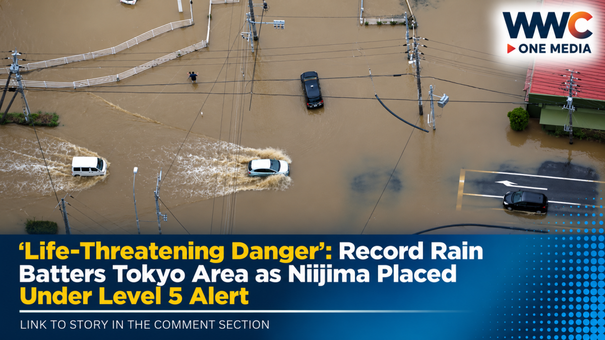
TOKYO — Torrential rain is pounding Tokyo and other parts of eastern Japan, triggering flooding fears, transport disruptions and the highest-level landslide warning for a village in the capital’s Izu Islands.
Japan’s Meteorological Agency issued a Level 5 Emergency Warning for landslides for Tokyo’s Niijima Village at 4:15 a.m. on Monday, Sept. 7, placing the area under the highest alert on Japan’s five-level warning system.
The warning means the risk has reached an extremely dangerous stage, with authorities urging people to take immediate action to protect their lives.
Heavy rain has also battered Tokyo, Kanagawa and Chiba prefectures, while weather officials warned that the danger could spread to other parts of Japan as an active seasonal rain front moves north.
Record Rainfall Triggers Highest-Level Alert
Niijima Village, part of Tokyo’s Izu Islands, has been hit by extraordinary rainfall.
Local reports said the island recorded historically high levels of rain, prompting the Japan Meteorological Agency to issue its Level 5 special warning for landslides.
The agency warned that the situation had become extremely dangerous and that landslides may already have occurred in some areas.
Weather officials urged residents not to take unnecessary risks and to prioritise immediate safety.
By later Monday morning, Niijima had recorded more than 450 millimetres of rain over 24 hours, according to Weathernews, dramatically surpassing previous records for the location. Other Izu Islands also experienced exceptional rainfall.
Tokyo, Kanagawa and Chiba Also Hit
The severe weather was not limited to the Izu Islands.
Heavy rain swept across the wider Kanto region, including central Tokyo and the neighbouring prefectures of Kanagawa and Chiba.
The Japan Meteorological Agency issued a Level 4 urgent warning for heavy rain in Chiba City early Monday.
Level 4 landslide warnings were also issued for much of the Izu Islands and parts of Kanagawa and Chiba.
Meanwhile, flooding concerns intensified in Tokyo, where a Level 4 warning was issued for the Zenpukujigawa River.
Authorities warned residents to remain alert for:
- Landslides and mudslides
- Rising and overflowing rivers
- Flooding in low-lying areas
- Sudden dangerous changes in weather conditions
Tokyo Schools and Train Services Disrupted
The extreme weather has already begun affecting daily life.
Some elementary and middle schools in Tokyo, Chiba and Kanagawa cancelled classes, while train operations were disrupted across the capital region.
According to The Japan Times, several major JR East lines were operating with fewer trains, affecting commuters during the Monday morning rush.
The disruptions underline how quickly severe weather can affect one of the world’s busiest urban regions.
For millions of people, Monday began with a warning to check transport services and weather alerts before travelling.
80 Millimetres of Rain in Just One Hour
The intensity of the rainfall has been staggering.
Radar analysis showed that around 80 millimetres of rain fell in and near Mikurajima Village in the Izu Islands in just one hour on Sunday evening.
Rainfall at that intensity can quickly overwhelm drainage systems, trigger flash flooding and increase the risk of landslides in mountainous areas.
Weather officials warned that even areas where rain begins to weaken may remain dangerous because the ground has already become saturated.
That means the risk of landslides can continue even after the heaviest rain has passed.
More Than 50 Millimetres an Hour Forecast
The Japan Meteorological Agency warned that intense rain could continue across several regions.
Forecasts called for:
- More than 50 millimetres of rain per hour in parts of the Kanto region
- Around 80 millimetres per hour in parts of Tokai
- Heavy rain across Kinki
- Intensifying rainfall spreading into Tohoku
Weather officials also warned that bands of particularly heavy rain clouds could develop.
The greatest concern is that concentrated bands of rain could dramatically increase the danger of flooding and landslides within a short period.
Authorities warned that conditions could deteriorate rapidly, especially in Kanto, Tokai and Tohoku.
Up to 300 Millimetres of Rain Forecast
The potential rainfall totals are equally alarming.
The Japan Meteorological Agency forecast that 24-hour rainfall through Monday evening could reach:
- 300 millimetres in Tokai
- 250 millimetres in Kanto-Koshin
- 200 millimetres in Tohoku
- 200 millimetres in Kinki
- 200 millimetres in the Izu Islands
Such large rainfall totals can create dangerous conditions even in areas that do not normally experience serious flooding.
Rivers can rise rapidly.
Slopes can become unstable.
And roads can become impassable within a matter of hours.
Tropical Storm Krovanh Could Add More Moisture
The dangerous weather pattern is being driven by more than just the seasonal rain front.
The Japan Meteorological Agency said the front, which had been located south of Japan’s main island of Honshu, was moving north.
At the same time, Tropical Storm Krovanh was expected to push warm, moisture-filled air toward the front.
That combination could help fuel more intense rain clouds.
Weathernews reported that the interaction between the active front, low-pressure systems and moist air was helping create highly unstable atmospheric conditions across eastern Japan.
Heavy Rain May Continue for Days
The danger may not end after Monday.
Weather officials warned that heavy rain could continue for the next three to four days, increasing the possibility of further flooding and landslides.
That is particularly concerning for communities that have already received exceptional amounts of rain.
When the ground becomes saturated, even moderate additional rainfall can trigger landslides or cause rivers to overflow.
Officials have urged people not to assume the danger is over simply because rainfall temporarily becomes lighter.
Level 5 Means Immediate Danger
Japan’s five-level warning system is designed to help people understand how urgently they need to act.
A Level 5 warning is the highest level.
It signals that a disaster is either imminent or may already be occurring and that people should take the best possible action to protect their lives.
Officials warned people near cliffs, valleys and landslide-prone areas to move to safer locations if it is safe to do so.
However, if travelling outside is already dangerous because of flooding, darkness or intense rain, authorities advise people to avoid unnecessary movement and seek the safest possible location inside a sturdy building.
The key message is simple:
Do not wait for conditions to get worse.
Residents Urged to Check Hazard Maps
Authorities are urging residents to monitor official weather updates and evacuation information.
People living in potentially dangerous areas have also been advised to check local hazard maps and identify the safest available locations.
Those in areas near:
- Steep slopes
- Cliffs
- Rivers
- Low-lying land
- Flood-prone roads
are being urged to pay particular attention.
The risk is especially serious overnight, when poor visibility can make evacuation more dangerous.
Officials have advised people to consider staying in safe buildings away from valleys and unstable slopes rather than waiting until an emergency evacuation becomes necessary.
Eastern Japan Remains on High Alert
While some parts of the Tokyo metropolitan area began moving past the peak of the morning’s heaviest rain, forecasters said dangerous conditions remained in eastern Kanto, the Izu Islands and parts of northeastern Japan.
Chiba and other eastern areas were still expected to face heavy rain, while Tohoku could remain at risk later in the day.
Even where rainfall weakens, the accumulated water means landslide and flooding dangers may continue.
That makes the situation especially dangerous because the threat is no longer only falling rain.
It is what the rain has already done to the ground, rivers and infrastructure.
A Dangerous Start to Monday in Japan
For Tokyo and much of eastern Japan, Monday began under an extraordinary weather threat.
Torrential rain.
Flood warnings.
Rising rivers.
Train disruptions.
School closures.
And a Level 5 emergency warning for landslides in one part of Tokyo.
The images of rain hammering the capital and surrounding prefectures are a powerful reminder that even one of the world’s largest and most developed urban areas remains vulnerable to extreme weather.
For now, authorities are urging one thing above all else:
Stay informed.
Avoid dangerous areas.
Do not wait until it is too late to act.
And as heavy rain continues to move across Japan, millions remain on alert for what the weather could bring next.
WWC ONE MEDIA J.M.D




Leave a Reply