
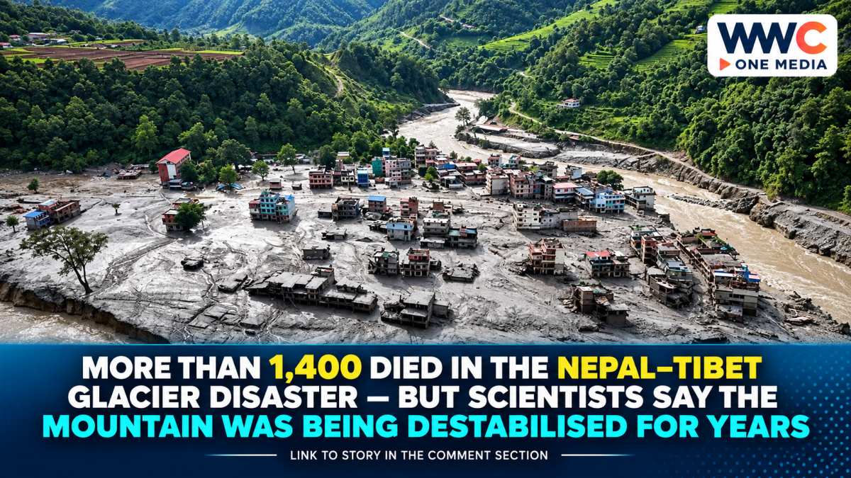
KATHMANDU — The disaster that tore through Nepal’s Trishuli River corridor in August looked sudden. Scientists now say some of the forces weakening the mountain had been building for decades.
On August 26, roughly 2 square kilometres of rock wall and overlying glacier ice broke away from Langtang Lirung, high in the Himalayas near Nepal’s border with Tibet.
The collapse fell around 1,400 metres, from roughly 5,150 metres above sea level to the valley floor.
What followed was not a conventional flood.
A rock-and-ice avalanche transformed into a high-speed debris flow packed with water, boulders, glacier ice and sediment. World Weather Attribution estimates the surge reached the Rasuwagadhi border area 22 kilometres downstream in only seven minutes, an average speed of about 188km/h.
The torrent destroyed border infrastructure, settlements, roads, bridges and hydropower facilities before racing much farther down the Trishuli system.
Now an international group of climate scientists says human-caused warming likely helped make the mountainside less stable before it failed.
That does not mean climate change was the only trigger.
It means the disaster may be an example of a more dangerous Himalayan future: climate change altering not just rainfall and temperature, but the physical stability of mountains themselves.
This was more than a glacier breaking apart
Early descriptions focused on a glacier collapse.
Satellite analysis later showed something substantially bigger.
Scientists examining post-disaster images found that a large section of bedrock itself failed, carrying glacier ice down with it.
University of Calgary geomorphologist Dan Shugar told AP that clearer satellite imagery showed a massive mountain-wall failure rather than simply ice breaking from the glacier.
That distinction matters.
A pure ice avalanche is one kind of hazard.
A collapsing rock face with glacier ice attached contains much more mass and can release extraordinary amounts of energy.
WWA calculates that when the rock and ice struck the valley floor, the impact released energy comparable to approximately a magnitude-5.5 earthquake.
The seismic waves were so strong that early monitoring initially contributed to speculation that an earthquake itself had triggered the disaster.
Scientists now believe the seismic signal largely came from the collapse.
Seven minutes separated the mountain from the border
The speed helps explain the enormous death toll.
After the rock and ice crashed into the valley, friction and impact likely melted part of the glacier.
The debris also struck buried ice and mixed with water already beneath the glacier, river water and sediment.
That created a moving mass with the destructive properties of both a landslide and a flood.
According to WWA’s reconstruction, the wall of water, rock and ice reached the Nepal-China border in about seven minutes.
It then struck Timure and Syabrubesi within roughly another 15 minutes.
Within about half an hour it was moving through parts of the Trishuli valley farther downstream.
The flood ultimately travelled around 200km to Devghat in less than seven hours, carrying an estimated 30.5 million cubic metres of sediment and debris through the corridor.
That left communities with almost no realistic evacuation window near the source.
Scientists say climate change was a destabiliser—not the sole cause
This is the most important scientific distinction in the story.
WWA did not conduct its usual type of attribution study in which researchers calculate exactly how much climate change increased the probability of a particular rainfall event or heatwave.
A collapsing mountain is more complicated.
Researchers cannot yet model every fracture beneath a glacier, every pocket of subsurface water or the mechanical condition of the mountain before it fails.
So the group explicitly says it has not determined whether this exact collapse would have happened in a world without human-caused warming.
Instead, researchers assessed the processes capable of weakening the slope.
Their conclusion is that climate change was an important destabilising influence acting on an already vulnerable mountain.
That is a stronger and more precise statement than either extreme of the debate.
It would be inaccurate to say global warming alone brought down Langtang Lirung.
It would also be misleading to say climate change had nothing to do with the conditions surrounding the failure.
The freezing line is climbing roughly 100 metres per decade
One of the clearest changes involves altitude.
WWA found that the height of the 0°C freezing threshold in the Himalayas has shifted upward sharply during recent monsoon and post-monsoon seasons—on the order of 100 metres per decade.
That matters because ice inside mountain fractures acts somewhat like natural cement.
When that frozen material remains solid, it can help bind broken rock together.
As temperatures rise, the ice thaws.
Fractures can weaken.
Meltwater can enter those cracks and increase pressure.
Eventually, rock that remained frozen for centuries can become significantly less stable.
AP reported that monitoring around 5,000 metres now shows some Himalayan rock and ground that once remained permanently frozen no longer staying frozen throughout the year.
In other words, warming is changing the mountain from the inside.
The glacier itself has also been shrinking
Regional glaciers have been losing mass for decades.
WWA estimates glacier losses equivalent to more than half a metre of thinning per year.
At Langtang Lirung, retreat has accelerated since 2010. Researchers estimate the glacier’s rate of recession increased from about 0.5 per cent annually over the previous two centuries to roughly 1 to 2.3 per cent a year during the past 16 years.
AP separately reported that Langtang Lirung’s glacier has retreated around half a kilometre since the 1990s.
Glacier retreat can destabilise neighbouring rock in several ways.
Ice can physically support—or “buttress”—mountain walls.
When that ice thins or retreats, stresses inside the exposed rock change.
At the same time, additional meltwater can penetrate fractures.
The mountain is not simply losing ice.
Its mechanical balance is being altered.
July and August were exceptionally warm
The immediate period before the failure was also unusual.
WWA found that the 12 months ending in August were exceptionally warm in the region, with July and August 2026 particularly extreme.
CNA, citing the study, reported Himalayan mean temperatures during August at roughly 5°C above normal, with around 1.5°C of that anomaly attributable to human-caused climate change.
The WWA analysis similarly found that human influence added roughly 1.5°C to July-August temperatures near the collapse site, while the estimated human-driven annual warming there is about 2°C.
That extra warmth matters because it increases snow and ice melt and raises the elevation at which precipitation falls as rain instead of snow.
Snow stores water temporarily.
Rain can enter the ground and fractures immediately.
An unusually snowy period may have added more water
The story is not simply “hot weather melted the glacier.”
Researchers identified a more complicated chain.
Unusually heavy precipitation in October 2025 contributed additional snow and water storage in the high mountains.
When warmer conditions arrived, some of that stored material melted.
At the same time, warming meant more precipitation was falling as rain rather than snow at higher elevations.
Together, those factors could have increased water pressure within existing fractures in the mountain.
That is why scientists describe the disaster as a cascade.
No single factor has to explain everything.
Geology, old earthquake damage, glacier retreat, permafrost thaw, precipitation and extreme warmth can interact.
The 2015 earthquake may still matter 11 years later
Climate change is also not the only long-term suspect.
In 2015, Nepal’s magnitude-7.8 Gorkha earthquake triggered a devastating avalanche in the same Langtang region.
WWA says the earthquake may have weakened bedrock and left sections of the mountain more vulnerable to later failure.
Researchers have observed persistently elevated landslide activity in parts of the Himalayas since that earthquake.
But scientists cannot yet quantify exactly how much the 2015 earthquake contributed to the 2026 collapse.
That uncertainty is central to responsible reporting.
The mountain may have been geologically damaged.
Climate warming appears to have weakened it further.
Then short-term warmth and meltwater may have helped push an already vulnerable slope closer to failure.
Nepal’s confirmed death toll has now reached 1,399
The scientific investigation is taking place while the humanitarian crisis is still unfolding.
Nepal’s National Disaster Risk Reduction and Management Authority told Reuters on September 16 that 1,399 people had been confirmed dead and about 5,200 remained missing.
Among those still unaccounted for were 636 foreign nationals.
Identification has been painfully slow.
Authorities had collected DNA from 1,206 bodies and 1,889 relatives of missing people, but only 105 bodies had been formally identified and returned to families by that point.
That is only about 7 per cent of recovered victims.
The numbers remain subject to revision as bodies are identified and missing-person lists are reconciled.
Tibet is facing its own enormous missing-person operation
Across the border in Tibet’s Gyirong County, Chinese authorities had confirmed 43 deaths and 519 missing as of September 5.
Among the missing were 261 foreign nationals from 23 countries, according to Xinhua.
More than 2,500 rescuers and 500 vehicles had been deployed, while drones conducted over 1,000 flights.
At the core disaster zone, Chinese state media reported a flood mark about 35 metres high, roughly equivalent to a 12-storey building, with mud and debris reaching depths of up to 16 metres in some locations.
Those figures help explain why casualty counts have taken so long to stabilise.
Victims may be buried under metres of debris or may have been swept far downstream.
Some of the most desperate searches are inside hydropower tunnels
Nepal’s hydropower industry was hit especially hard.
More than 12 hydropower plants were swept away or severely damaged, and around 900 power-station workers were among those reported missing earlier in September.
Rescuers have spent weeks digging into blocked tunnels packed with rock, mud and debris.
There have also been extraordinary survivals.
Mechanical foreman Sanjay Sah survived around nine days trapped in darkness inside the Upper Trishuli 3A hydropower complex, living on floodwater and mountain seepage until rescuers reached him. Another worker was rescued from the same complex.
Those rescues provided rare moments of hope.
But as the weeks pass, the chances of finding large numbers of survivors diminish.
The disaster wiped out about a tenth of Nepal’s generating capacity
The flood has also become an energy crisis.
Hydropower supplies almost all of Nepal’s electricity and had become an increasingly important export earner.
The destruction wiped out roughly 10 per cent of Nepal’s generation capacity, forcing the country to halt electricity exports and seek emergency imports from India.
India has approved electricity exports of up to 654 megawatts for 18 hours a day through December 31 to help Nepal cover the shortfall.
The irony is difficult to ignore.
Hydropower is one of Nepal’s main low-carbon development assets.
But those facilities are often built in the same steep river valleys increasingly exposed to climate-amplified mountain hazards.
Nepal says it needs about US$5 billion just for initial rebuilding
Kathmandu estimates that the first phase of recovery could require around US$5 billion.
Nepal is seeking financial help from richer governments, the World Bank, Asian Development Bank and other international partners while framing the catastrophe as a climate-justice issue.
Officials argue that Nepal has contributed only a tiny share of historic greenhouse-gas emissions yet faces disproportionate costs from warming.
The disaster destroyed or damaged roads, bridges, communications networks, homes, power stations and important cross-border trade infrastructure.
That makes the climate question about more than the physics of one collapsing mountain.
It is also about who pays when warming magnifies risks in countries with relatively little responsibility for creating the problem.
Could an early-warning system have stopped it?
Probably not near the collapse site.
That is another striking conclusion from WWA.
Nepal has built flood-warning systems that can save lives when rainfall or upstream river levels provide hours of warning.
But this event unfolded at extraordinary speed.
WWA concluded that no existing early-warning system could have provided enough lead time to prevent the worst impacts in the areas closest to the collapse.
A wall of debris covering 22km in seven minutes simply moves faster than conventional evacuation systems.
That does not mean monitoring is pointless.
Better satellites, slope radar, glacier measurements and cross-border data could identify unstable areas and help governments decide where infrastructure should—or should not—be built.
But scientists say there are limits to adaptation when entire communities and critical infrastructure are concentrated inside narrow Himalayan valleys.
The disaster has reopened questions about Nepal-China data sharing
Just three months before the collapse, Nepalese and Chinese officials had discussed stronger cooperation on glaciers, river levels and flood hazards.
Nepal sought greater access to upstream monitoring information.
Two Nepali officials later told Reuters that they had wanted more glacier-risk and water-level data from China, while Beijing said information had been shared in a timely manner and cooperation remained strong. No expert cited by Reuters blamed either country for causing the disaster.
After the catastrophe, China began providing Nepal with daily meteorological, hydrological and glacier updates, according to Chinese authorities.
The episode demonstrates why Himalayan disaster forecasting increasingly has to cross political borders.
Water, glaciers and landslides do not stop at customs posts.
Scientists warn the problem is much bigger than Langtang
The Hindu Kush-Himalaya contains tens of thousands of glaciers feeding some of Asia’s most important rivers.
A report released this month found glacier mass loss accelerating while only 21 glaciers were being continuously monitored on the ground out of an estimated 40,000 across the wider Hindu Kush-Himalaya region.
As glaciers retreat, some rivers may initially receive more meltwater.
Eventually, however, the region approaches “peak water”—the point after which glacier-fed flows begin declining.
At the same time, retreating ice can create unstable glacial lakes and expose previously frozen mountain walls.
That means warming can produce seemingly contradictory risks:
too much water suddenly,
then potentially too little water over the longer term.
The most important finding is what scientists did not claim
WWA’s new assessment is powerful precisely because of its restraint.
Researchers did not say:
“Climate change caused the mountain to collapse.”
They said something more scientifically defensible.
The slope was geologically vulnerable.
The 2015 earthquake may have weakened it.
But warming glaciers, degrading permafrost, higher freezing levels, extreme temperatures and additional meltwater made the conditions less stable.
That distinction should stay in every headline and rewrite.
Climate change is not required to create Himalayan landslides.
The Himalayas have always been geologically active.
The danger is that warming is now acting on top of that natural instability.
The mountain collapsed in minutes. The conditions took decades to build.
That may be the most important way to understand the August 26 disaster.
To the people in the valley, it happened almost instantaneously.
A mountainside failed.
Seven minutes later, the border was overwhelmed.
Within hours, the destruction stretched hundreds of kilometres downstream.
But the mountain had been changing for far longer.
Glaciers were thinning.
The freezing line was moving uphill.
Permafrost was thawing.
Rock once held together by permanent ice was being exposed to repeated warming.
And an earthquake-damaged landscape may have been carrying weaknesses for more than a decade.
That is why the Nepal-Tibet catastrophe is no longer only a story about one glacier.
It is becoming a warning about what happens when a rapidly warming climate meets some of the youngest, steepest and most unstable mountains on Earth.
The flood lasted hours.
The rebuilding will take years.
And scientists say some of the changes destabilising the Himalayas have already been locked in by warming that has happened.




Leave a Reply